Community Highlights

These highlights feature efforts by the community that are bringing us closer to a modern vision for hydropower. Interested in featuring your project? Contact the Vision team.
The sustainable development and operations icon is a maroon fish next to a gear.

ARkStorm 2.0 Informs Dam Safety Planning

Tags
Sustainable Development and Operations
Safe and Secure Infrastructure
Sectors
Government
Other stakeholders

Long-lived hydropower infrastructure must be kept well-maintained and periodically modernized to ensure functionality and safety—particularly in the face of altered rainfall patterns and flood risk due to climate change. To inform emergency and safety planning in the state of California, a consortium of researchers funded by the Yuba Water Agency, California Department of Water Resources, and the National Science Foundation developed ARkStorm 2.0, which simulates possible 1000-year extreme storm and flood scenarios. Based on historic megastorm events in California, ARkStorm 2.0 also incorporates the effects of climate change and advanced climate and hydrological science to improve simulations of these possible weather events. The information in ARkStorm 2.0 about extreme storm and flood scenarios can help inform dam safety investments and emergency planning, to prepare for extreme weather events that can lead to spillway damage, downstream erosion, and even dam failure. 

Learn more about ARkStorm 2.0.

Published on July 15, 2024
The sustainable development and operations icon is a maroon fish next to a gear.

Forecast Informed Reservoir Operations

Tags
Sustainable Development and Operations
Environmental Protection
Sectors
Government
Other stakeholders

Water management and environmental stewardship are key considerations for sustainable hydropower operations. To meet the challenges of growing water demand and the effects of climate change on water resources, hydropower operators need the most accurate weather and water predictions available. Developed by the Center for Western Weather and Water Extremes (CW3E), Forecast Informed Reservoir Operations (FIRO) is an approach to reservoir operations that leverages improved weather and water forecasts to better inform water management strategies. FIRO relies on collaborative efforts between federal and state agencies, experts, and stakeholders to use the latest science to develop approaches that enable operational flexibility and support water management in the face of climate change. 

Learn more about FIRO and ongoing FIRO projects in the Western United States at the CW3E website

Published on April 10, 2024
Image
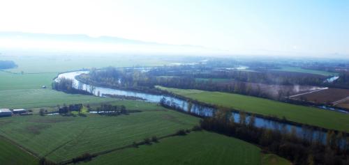
Aerial view of Willamette River
The Sustainable Rivers Program has helped determine environmental flow requirements on many rivers, including the Willamette River shown here. (Photo by U.S. Army Corps of Engineers)

Sustainable Rivers Program

Tags
Sustainable Development and Operations
Coordinated Operations
Sectors
Government
Other stakeholders

River infrastructure, such as locks and dams, alters water flow patterns in ways that can affect river species and habitats. The Sustainable Rivers Program is a collaborative effort between the U.S. Army Corps of Engineers and The Nature Conservancy to find sustainable ways to manage river infrastructure and water flows that maximize benefits to both people and nature. Specifically, the program helps determine environmental flow requirements for rivers—the water flow on either side of a dam necessary to support river species and habitats—and operating plans for infrastructure that use these flows. The program takes a collaborative approach that combines science and stakeholder engagement to review new environmental flow patterns and modernize river infrastructure. Since 2002, the Sustainable Rivers Program has grown to include 44 rivers and 90 associated reservoirs and dams. 

Learn more about the Sustainable Rivers Program from The Nature Conservancy and U.S. Army Corps of Engineers

Published on March 11, 2024